Layers Upon Layers of Map Data at Your Fingertips
Do you ever wake in the middle of the night with a deep and intense need to know exactly which California flood plains also fall within high-risk fire zones? Have you ever taken a long drive and felt that insatiable compulsion to pull over, walk deep into the heart of a pistachio farm, and learn every conceivable fact about the parcel of land beneath your very feet?
We totally sympathize.
But maybe you just need to know California parcel data for your job. Real estate appraisers, insurance risk managers, remediation services, city planners – you’re all people who need to know multiple pieces of information about a parcel. And nothing makes visualizing that data easier than the multiple visual layers available in ParcelQuest.

California Map Layers Drawn by Experts
Maps are reflections of the world, and when your work has real-world impact, those reflections need to be totally accurate and up to date. That’s why we draw and manage the parcel layer ourselves, using our own dedicated team to convert APN Map changes into up-to-the-minute accurate parcel layer updates.
The rest of our map layers come from the most authoritative and accurate sources we can find. Because who knows fires better than CalFire? Who has better flood data than FEMA? A better understanding of coastlines than the CA Coastal Commission?
No, really, tell us. We want to know so we can get all their maps.
Every Kind of Layer You Can Think Of (And Maybe Some You Can’t)
Imagine a map of the state of California. Now imagine that you can draw a custom area so you can track and analyze just the parcels within that custom shape.
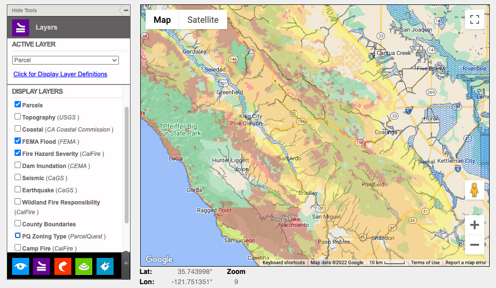
Now imagine unleashing the ultimate power of multiple map layers to cross-reference information from numerous sources:
- Topographical maps from the U.S.G.S. showing elevation, latitude, longitude, the location of rivers, mountains, valleys, and other landforms.
- Dam Inundation maps from CEMA showing which areas are most likely to be affected by catastrophic dam failure.
- Earthquake maps from CaGS showing all of the California fault lines and segments that might constitute a hazard to structures built over them.
- Seismic maps from CaGS to identify seismic hazards, including liquefaction hazards and landslide zones that could pose a risk to developments built in an area.
- Wildland Fire Responsibility maps from CalFire showing what agencies are responsible for fire prevention and suppression in any given geographic range.
- Fire Hazard Severity maps from CalFire, showing areas at the greatest risk for wildfires.
- Flood maps from FEMA showing estimated flood risk and designating levels of flood hazard.
- Coastal maps from CA Coastal Commission showing areas where land and water use are regulated by coastal zone designations.
- Zoning maps for multiple categories, including Residential, Rural, Commercial, Industrial, Agricultural, Recreation, Public, Planned Development, Mixed Use, Unclassified and Miscellaneous.
- Crop maps showing where various agricultural products are grown, including pistachios, almonds, strawberries, and Christmas trees.
You can turn on as many of these layers as you want to pinpoint the specific information you need. All maps are updated as necessary when their sources have new data to share or new updates become available. And we’re not shy about adding super-specific map layers that serve a need, like the Camp Fire layer showing the fire boundary and severity of damage caused by the recent Camp Fire wildfire.
What kind of information do you need? We probably have it. And if we don’t, we can add it. In fact, we’re adding map layers all the time based on what our customers are asking for, what’s timely and relevant, what deep parcel-related mysteries are keeping us up at night.
So if you haven’t explored the full power of ParcelQuest, sign up today to see what we have to offer. Or, if you have specific requests or questions, you can give us a call at 1-888-217-8999.